GPS Based Surveying for Mapping of Canal Alignment in GIS Environment - A Case Study of a Branch Canal of Alimineti Madhava Reddy project, Nalgonda District, Andhra Pradesh, India.
Jayachandra Kannemadugu and D. Punyasheshudu2
1Sr.GIS Consultant, Hyderabad,India.
2Department of Physics, Rayalaseema University, Kurnool, Andhra Pradesh, India
Article Publishing History
Article Received on :
Article Accepted on :
Article Published : 03 Jul 2014
Article Metrics
ABSTRACT:
Much more challenging than that of groundwater is the improvement of performance of canal systems, which will remain the dominant water transfer technique in developing countries in the future. The standards used for design of irrigation canals in many countries have not kept up with the development of new technologies. Global Position Systems ( GPS) and Geographical Information System (GIS) integrated systems have emerged in the recent years as powerful tools in conducting large scale surveys for mapping and to create spatial data base of any Geographical area in any scale and integration of non-spatial information, modeling, analysis and generating statistical data according to the nature of application. This article employs spatial analysis techniques to extract the extent of land components of the individual owners/enjoyers which would be acquired by the Government for constructing the canal and to make the compensations against their land.
KEYWORDS:
Canal, GPS survey, alignment, GIS, Spatial analysis, Land extent, Government, Revenue village.
Copy the following to cite this article:
Kannemadugu J, Punyasheshudu D. GPS Based Surveying for Mapping of Canal Alignment in GIS Environment - A Case Study of a Branch Canal of Alimineti Madhava Reddy project, Nalgonda District, Andhra Pradesh, India. Orient. J. Comp. Sci. and Technol;7(1)
|
Copy the following to cite this URL:
Kannemadugu J, Punyasheshudu D. GPS Based Surveying for Mapping of Canal Alignment in GIS Environment - A Case Study of a Branch Canal of Alimineti Madhava Reddy project, Nalgonda District, Andhra Pradesh, India. Orient. J. Comp. Sci. and Technol;7(1). Available from: http://computerscijournal.org/?p=712
|
Introduction
The Govt. of Andhra Pradesh has proposed and implementing many irrigation projects across the state as a major activity. Many new canals and sub canals / distributaries are proposed to construct under the command areas of these new and existing projects. Mapping of canal alignments from a specific location, linked to a river, reservoir or a major canal with a pre-planned direction and path designed by the irrigation department is the key component in these projects. The concerned departments have to accurately identify the extent land to be acquired for this purpose which generally covered under private land extents. The enjoyer wise land areas needs to be correctly calculated other wise it will be a grate loss to both enjoyers and government.
Application of GPS and GIS technologies will help in identifying all the spatial/non-spatial details accurately and mapping in a lesser time. Many advanced tools are available in the GIS software to speed up the geo-processes and integration of the non-spatial information in digital environment and there by helping the authorities in generating the necessary analysis and statistics in a short time, where as the same task may take few days to weeks through the conventional methodologies.
The present paper envisages the conduct of a GPS based survey to map the correct alignment and to identify the extent of land both survey number wise and enjoyer wise which is to be acquired for laying the canal.
2.1 Study area
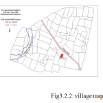
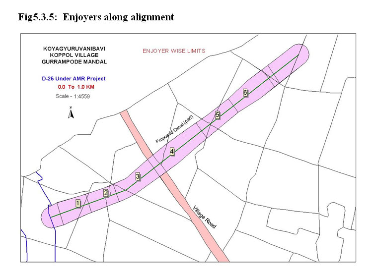
One of the branch canal proposed under the Alimineti Madhava Reddy Right Canal of Nagarjunasagar reservoir has been chosen as the project study area. The canal was proposed for a stretch of 18 kilometers out of which only a small part of the canal ( ie, first one KM part) is being used for the present purpose. The location of the canal is falling in the revenue limits of Koyaguravanibavi village, a hamlet of Koppole Revenue village of Gurrampode mandal of Nalgonda District, Andhra Pradesh.
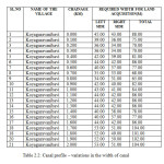
2.2 Canal profile
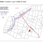
The length of the branch canal is 18 Kms. The width of the canal is varying at every 100 meters by a radial distance ranging 35 – 55 meters. The particulars of variations in the width of the alignment are given in the below table2.2.
3.1 Field Survey
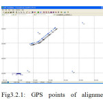
The field survey conducted to record various positions connected to the canal alignment and village control points for geo-referencing purposes. The GPS receiver used in the survey was of Trimble which gives an accuracy of 1- 2.5 meters.
In the present case, ground pits are made along the alignment at a distance of every 25 meters and stone marking of 100 meters was also marked. The land enjoyers along the canal are also invited for assisting in identifying their correct boundaries. Keeping the project requirements ie. Correct path (alignment) and the limits of enjoyer’s wise land extent, all these pits and the position of enjoyer’s limits are recorded in the GPS receiver. The Pathfinder tool was used to connect the Trimble receiver to a PDA and the coordinates of each and every position of the field marks/pits are recorded.
3.2. Mapping in GIS
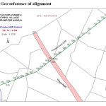
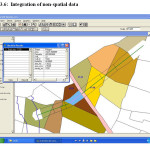
GPS Track Maker software tool was used to save the recorded points into a text file and the spatial data in shape file format was generated using ArcView software. After spatial process such as topology creation, geo-reference with revenue boundaries map, the required thematic maps were generated.
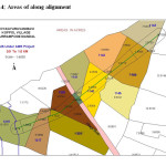
4. Digital map of the village(s):
The cadastral maps of the villages through which the proposed canal passes were digitized ( in the present case the village map of koyaguravanibavi village) using scanning-vectorisation methods. GIS conversion and geo-reference by using the control points collected from the field survey was done to these maps. All the maps are projected to polyconic projection to generate statistical details.
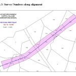
The final themes created in the project are – Canal alignment , Enjoyer wise land extent points, Revenue village map, buffer theme ( with actual radial distances), Union map of alignment with survey Numbers and the Union map of alignment with enjoyer limits.
5.1 Results & conclusions
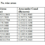
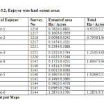
The statistics generated under the work are,
a) Survey No. wise land area in hectares/acres covered under proposed canal.
b) Survey No. wise left over area after separating the canal area.
c) Survey No. wise side areas ( left side, right side)
d) Enjoyer wise areas
The conventional way of doing such surveys and generating the statistical database is very lengthy process and time consuming. It was observed that for a surveyor, it is hardly 6-8 Kms of stretch could be the maximum possible work in period of one month. At this rate the task of finalizing the statistical databases for the government records, will be delayed which will effect the rest of processes. On the other hand, by using latest GPS and GIS technologies and applying the methodologies followed in the current work, the target of completing the task of any size could be very comfortably achieved within the stipulated time. With the present experience, the work of 3-5 Kms stretch could easily be managed in a single day.
5.2 Advantages
- The entire process of mapping and generation of required statistical data are in digital environment and maintenance of data is very convenient.
- Permanent and any no. of copies at any time could be generated in short time.
- Time period.
- Expenditure could be reduced in comparison with conventional procedures.
- Less number of manpower can handle the field task
- Accuracy
Note: The accuracy of the GPS receiver shall be within 1 meter.
Reference
- Peter A Burrough and Rachael A. Mc Donnell (2000), Principles of Geographical Information systems. Oxford University Press.
- Morton E. O’Kelly, The Impact of Accessibility Change on the Geography of Crop Production: A Reexamination of the Illinois and Michigan Canal Using GIS
- Ministry of Water Resources, Ninth National Water Convention Proceedings, November, 2001.
- V. M. Chowdary, N. H. Rao and P. B. S. Sarma, GIS-based decision support system for groundwater assessment in large irrigation project areas.
- Navstar GPS System Surveying for Civil Engineering, Topography and Construction- by Brown, Blaine
- Herman Depeweg and Elga Rocabado Urquieta , GIS tools and the design of irrigation canals.
- P.S. Roy and V.V.Rao, Remote Sensing and GIS – Water Management.
- Geographic Information Systems (GIS) and mapping.- By Arnold Ivan Johnson, C. Bernt Pettersson, James L. Fulton.

This work is licensed under a Creative Commons Attribution 4.0 International License.